I tried to document the drive from Ellensburg, east of the Cascades, to the Pacific Ocean and back to the Puget Sound area. Many of the pictures were taken from the little MR2 Kenny lent us to drive, so the perspective is low. That makes for some interesting shots sometimes.
So here we are heading west from Ellensburg. East of the Cascades the terrain is wide open with lots of farmland and not a lot of trees except in the mountains, at least along I90. One of the things we've discovered is that although we normally like to take the backroads, some of the interstates have great views, too. I90 through the Cascades is one of them.


 This is an interesting tunnel in that it is a tunnel going west but the road is outside the tunnel going east.
 Snoqualmie Pass is a ski area along I90. In the winter the weather is miserable here. On the top it's usually snowing. On the east side it can also be snowing but on the west side it's usually raining. And at 3044 feet it's lower than the elevation of where we're building our house.
 These are shots along Hwy 101 on the Olympic Peninsula. These aren't exactly rainforest pictures, but the forest is much thicker west of the Cascade mountains than it is east and it's thickest on the Olympic Peninsula where some areas get as much as 140 inches of rain each year.
 This is the Quinault Lodge. We didn't stay here this time. We just made a side trip. It's on Lake Quinault and in the Quinault Rain Forest.
 It's one of the grand old National Park lodges. This is the lobby.
 And this is the lake side.
 Now, back to the drive. We took the ferry from Edmonds to Kingston.

 This is one of the marinas on the Edmonds side.
 This body of water is Puget Sound.
 Here's Trout reading while we cross.
 Our destination was Kalaloch. It's a beach. It's a lodge. It's a restaurant. There are rooms in the lodge, cabins overlooking the cliffs to the beach and motel-like rooms.
 We ended up in one of the motel-like rooms. It turned out to be a 2 bedroom place on the end with a fireplace.
 This was our back balcony. At Kalaloch there are no phones except at the lodge, there's no TV and no cell reception. We spent 2 nights. Trout slept until noon the day in the middle.
 Because we were in an end unit, we had windows on 2 sides. This was the view out one of the side windows.
 And this was one of the views from the balcony. The website said we had peekaboo views. That meant that there were cabins in front of us, but because we were upstairs we could see over them.
 Of course, I got up earlier than Trout that day in the middle. I walked up to the lodge for breakfast on my own. I took these pictures along the way from the cliff above the beach.


Later that afternoon, we got down on the beach. This is a very dramatic and dangerous beach area. These large logs can come in during storms, but also rogue waves can bring them in on a seemingly calm day. People have been killed here by them.
 There's a very pretty little calm inlet here that I just love. It's just below the lodge.

 Here's Trout sort of reading and contemplating the beach.
 We think these birds were pelicans, but we don't really know what they were.
 At this time of year, the smelt come in to spawn in the shallower water and the birds just love that. They would dive and dive for the fish.
 I can't resist taking "arty" pictures. None of these was arranged, but all were cropped.


 This is the other end of the log Trout was sitting on.
 We stayed until the sun started to set and it was time to go to dinner in the lodge.

 We finished dinner before the sun finally set. I got these pictures from our balcony.

 The next day we started the drive back to the Puget Sound area. We stopped in Gig Harbor to have lunch with Joan and Gerry. Joan worked with me at Weyerhaeuser and Gerry is still a pilot for United Airlines. When Lee was about 16 we took him to meet them and to talk to Gerry about the job.
 There's a very pretty little calm inlet here that I just love. It's just below the lodge.
 Here's Trout sort of reading and contemplating the beach.
 We think these birds were pelicans, but we don't really know what they were.
 At this time of year, the smelt come in to spawn in the shallower water and the birds just love that. They would dive and dive for the fish.
 I can't resist taking "arty" pictures. None of these was arranged, but all were cropped.

 This is the other end of the log Trout was sitting on.
 We stayed until the sun started to set and it was time to go to dinner in the lodge.
 We finished dinner before the sun finally set. I got these pictures from our balcony.
 The next day we started the drive back to the Puget Sound area. We stopped in Gig Harbor to have lunch with Joan and Gerry. Joan worked with me at Weyerhaeuser and Gerry is still a pilot for United Airlines. When Lee was about 16 we took him to meet them and to talk to Gerry about the job.
So this is Gig Harbor from the farthest end of it.
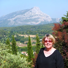
 And here's the infamous Mt. Rainier peeking above the trees on the hill to the left.
 Some of you may have heard of the 1st Tacoma Narrows bridge called Galloping Gertie. It was finished in 1940 and collapsed about 5 months later. The span on the left is what replaced it 10 years after that. When traffic to and from Gig Harbor got more than too bad, a second span was added. We got to drive over the new one on the right this trip.

 As we headed east, we got closer to Mt. Rainier. Yes, it is an active volcano.
 Along the road, we encountered the usual large trucks hauling loads. They look bigger from the passenger seat of an MR2. This is a hay truck along I90.
 But you can see hay trucks most anywhere. You don't often see log trucks, though.
 Close to the water, especially on the Olympic Peninsula, these signs become more frequent.
 This one is common close to the volcanoes. I have to admit, I didn't take this picture. I forgot to get one so I pulled this off a picture sharing website.
 That pretty much concludes our trip to WA this time. Neither of us got sick or had any health emergencies. We got back to Tucson safe and sound. The 3 hour flight was uneventful -- especially since we both slept almost all the way.
 And here's the infamous Mt. Rainier peeking above the trees on the hill to the left.
 Some of you may have heard of the 1st Tacoma Narrows bridge called Galloping Gertie. It was finished in 1940 and collapsed about 5 months later. The span on the left is what replaced it 10 years after that. When traffic to and from Gig Harbor got more than too bad, a second span was added. We got to drive over the new one on the right this trip.
 As we headed east, we got closer to Mt. Rainier. Yes, it is an active volcano.
 Along the road, we encountered the usual large trucks hauling loads. They look bigger from the passenger seat of an MR2. This is a hay truck along I90.
 But you can see hay trucks most anywhere. You don't often see log trucks, though.
 Close to the water, especially on the Olympic Peninsula, these signs become more frequent.
 This one is common close to the volcanoes. I have to admit, I didn't take this picture. I forgot to get one so I pulled this off a picture sharing website.
 That pretty much concludes our trip to WA this time. Neither of us got sick or had any health emergencies. We got back to Tucson safe and sound. The 3 hour flight was uneventful -- especially since we both slept almost all the way.