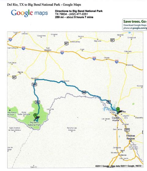
 Here we are passing on the other side of the railroad bridge over Lake Amistad.
 Ronald told us to be sure to stop to look at the Pecos River and some guys at the motel told us to stop at the "high" bridge. It turned out that they were one in the same.
 These pictures are for all of you who thought (as I did) that the Pecos River was just some little mostly dry bed stream.
 You drive along this largely flat landscape and there's this big canyon with water in it.
 After passing the river we hit a lot of rolling hills with exposed limestone in the road cuts through them.
 We thought we would have lunch somewhere along the way, but we saw no place to do that, so we just kept driving. That's why we take a cooler with drinks and some emergency food on these trips.
We showed my old person national park pass and headed into the Park. Being spoiled by northern AZ and southern UT, we were saying, "what's the big deal?" about Big Bend.
 We started into the mountains that house our accomodations, and this "sky island" (as the mountains in the Tucson area are called) start looking a little more interesting.


 We drove through a narrow, winding canyon with oaks and pinyon pine until we got to the restaurant and lodge area. Lest you think it's someplace fancy, there was no cell service, and there were no TVs and no phones in the rooms.
We stayed at the Chisos Mountain Lodge in one of the Emory Peak Lodge Rooms. In fact, the room shown looks just like ours.
On the day of arrival we had a late lunch at the restaurant, went back to the room, had major naps and then went back to the restaurant for dinner.
Rested the next morning we had breakfast and decided to get in the car and explore the (paved) roads of the park.
First we went east. We went to a campground right on the Rio Grande. There were lots of out-of-state campers basking in the sun by their RVs. We made our way through the cane to the river. And here it is. That's Mexico on the other side.

 A little ways away from that area, we found a spot where we could walk across a little cove in the cane to get a different view of the river. This brought back childhood memories of fishing or gigging frogs in places that looked just like this.
 This shows the river and the cane from a higher perspective. It looks like reeds from here but down at the water level it's a different story.
 Looking toward Mexico.
 Heading back to the car.
 Sand dunes on the Mexican side.
 Walking through the cane.
 We left the campground and drove farther east. There was a viewpoint, so we pulled off there. This is Boquillas Canyon Overlook.
 As mentioned many times before, Mexico is right across the river. These guys are waiting there for someone to buy some of their crafts that are sitting on a rock at this overlook. When you buy something, they ride across the river to get the money.
 On the far rock are their wares. The little town of Boquillas del Carmen is visible on the Mexican side of the river.
 This is a close up of the things they sell.
 There are all kinds of warnings about buying from them. Fines are possible if someone is caught with this stuff and they don't have a receipt from a Park vendor.
It's a sad situation for this little town. People used to be able to cross here and go easily back and forth to work on the US side and shop and eat on the Mexico side. Then the paranoia hit and the crossing was closed. It totally destroyed this little town's economy.
There is hope, though. The crossing is going to be reopened and managed electronically with limited hours for going back and forth. That should make it better for the people on both sides of the border here. If you click on the Park map, you can see that this would not be a prime location for any bad people to come across. All the roads on the Mexican side are dirt or so primitive that 4WD is required.

 We learned that about 100 years ago there was a mining operation in this area. The ore was taken out of Mexico and brought to the US side on a very long tram over the river.
We left the east side of the Park and headed west. These are the Chisos Mountains where we were staying.
 I particularly wanted to see Santa Elena Canyon.
 This big cliff is on the Mexican side.
 The canyon cuts through it. In the canyon, Mexico is on the left and the US is on the right.

 In this picture, looking down river, Mexico is on the right.
 To get down to the canyon, we had to cross Terlingua Creek on these stones, or in other places. I was glad I had on my Gore-Tex boots and that it was very shallow.
 Trout's about as close to Mexico as he can get without wading out to the middle of the very shallow Rio Grande.
 It's maybe 6" deep at this point.
He had been complaining about not seeing any real canyons, but he had to admit that this is a canyon.


 Of course I had to show it off.
 They said it was an easy hike up to view the canyon. Can you see the rail in this picture? That doesn't say easy to me.
 I had to take one more picture of these cliffs.
 We left the river and headed back toward the main road. On the way down we saw a lookout called Mule Ears. This is it from the back side.
 We noticed all the colors of the rock faces of the mountains. Even a good camera doesn't do them justice.
 We really liked the green.

 This is Santa Elena Canyon from the road out of the park.
 Then the road turned slightly north and we started seeing a totally different type of scenery.

 We turned west on 170, drove through what's left of Terlingua and got ready for miles and miles with no people or services and almost no cars.


 We didn't stop, but Lajitas is a nice little resort town west of Terlingua. It's mayor was a beer-drinking goat named Clay Henry.
 On we drove over and around hills and mostly always along the Rio Grande. Mexico is on the left. We're in the US on our road.
 This was a pretty good softy canyon.
 Sometimes it's hard to tell if something is on Mexican or US soil. These ranch buildings are on the American side.
 Any geologists out there? The white looks like caliche to me.
 These small roads in Texas rarely have rest stops with bathrooms, but there often are picnic tables. I liked these ones.

 Trout loved the blind corners on this road -- especially if there was some off-camber elevation change as well.

 There was lots of evidence of past volcanic activity in the Big Bend area.


 Remember, Mexico on the left, US on the right.
 This is an example of the red cliffs Ronald told us about.

 If you look closely you can see Trout's favorite sign in the lower right of this picture.
 Here's a close up. He really preferred the ones with no suggested speed, but I didn't get a picture of one of those.
 We came out of the mountains, turned inland on US 67 at Presidio and it was another world. This is the part of Texas where the movie, Giant, was filmed. By the way, when I was growing up, Presidio consistently was cited as having the highest temperatures in the summer. Trout wanted to go through there because of the Larry McMurtry novels that mention it, and the Mexican town of Ojinaga across the river.
 There's nothing but grassland as far as you can see.
 Then you get to Marfa. It's a town of many attractions as the linked Wikipedia article says. The Hotel Paisano, where many of the actors who were in Giant stayed, is now restored. Although dead now for over 15 years, Donald Judd still has a major presence there in the form of the foundation that preserves his work and spaces in the town. Marfa is way more arty than you might imagine for its size and location.
 From Marfa we headed west on US 90 toward Van Horn. Van Horn has an old hotel like the one in Marfa, but for us its Dairy Queen was a quick stop before getting on IH 10 toward Las Cruces.
One big surprise for us was a large pecan orchard southeast of Van Horn on US 90. I'm not kidding when I say it went on for MILES and it was so deep that the ends of the rows of trees were barely visible.
 I always feel like we're home when we get to Texas Canyon. These pictures provide a glimpse of the large, tumbled rocks there. It's just east of Benson on IH 10.


 Texas Canyon is yet another fine example of some of the great terrain easily visible from an interstate highway.


 Of course I had to show it off.
 They said it was an easy hike up to view the canyon. Can you see the rail in this picture? That doesn't say easy to me.
 I had to take one more picture of these cliffs.
 We left the river and headed back toward the main road. On the way down we saw a lookout called Mule Ears. This is it from the back side.
 We noticed all the colors of the rock faces of the mountains. Even a good camera doesn't do them justice.
  We really liked the green.
The next morning we left Big Bend after a quick breakfast in the room. We drove out of the park to the west. Because it was to be our longest day of driving, I had planned to take Texas Hwy 118 up to Alpine, but Trout talked to Ronald and he recommended that we take Farm to Market Road 170 along the Rio Grande, so that's what we did.
I am so glad we did that. It was a beautiful and fun drive and it didn't take that much longer than the other route. But next time, coming or going, we want to go through Alpine and the Davis Mountains where the McDonald Observatory is.
 This is Santa Elena Canyon from the road out of the park.
 Then the road turned slightly north and we started seeing a totally different type of scenery.
 We turned west on 170, drove through what's left of Terlingua and got ready for miles and miles with no people or services and almost no cars.
The Terlingua area is pretty touristy in a rough sort of way. My favorite shop along the road was called Passing Wind. It seemed to specialize in kites and other things that wind might activate.


 We didn't stop, but Lajitas is a nice little resort town west of Terlingua. It's mayor was a beer-drinking goat named Clay Henry.
 On we drove over and around hills and mostly always along the Rio Grande. Mexico is on the left. We're in the US on our road.
 This was a pretty good softy canyon.
 Sometimes it's hard to tell if something is on Mexican or US soil. These ranch buildings are on the American side.
 Any geologists out there? The white looks like caliche to me.
 These small roads in Texas rarely have rest stops with bathrooms, but there often are picnic tables. I liked these ones.
 Trout loved the blind corners on this road -- especially if there was some off-camber elevation change as well.
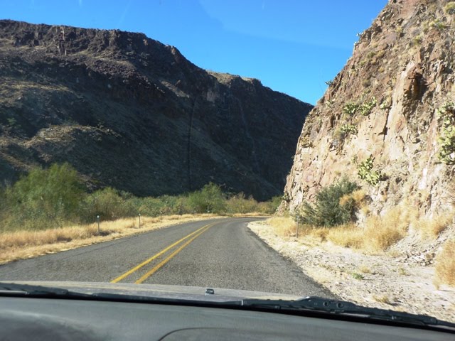
 There was lots of evidence of past volcanic activity in the Big Bend area.

 Remember, Mexico on the left, US on the right.
 This is an example of the red cliffs Ronald told us about.
 If you look closely you can see Trout's favorite sign in the lower right of this picture.
 Here's a close up. He really preferred the ones with no suggested speed, but I didn't get a picture of one of those.
 We came out of the mountains, turned inland on US 67 at Presidio and it was another world. This is the part of Texas where the movie, Giant, was filmed. By the way, when I was growing up, Presidio consistently was cited as having the highest temperatures in the summer. Trout wanted to go through there because of the Larry McMurtry novels that mention it, and the Mexican town of Ojinaga across the river.
 There's nothing but grassland as far as you can see.
 Then you get to Marfa. It's a town of many attractions as the linked Wikipedia article says. The Hotel Paisano, where many of the actors who were in Giant stayed, is now restored. Although dead now for over 15 years, Donald Judd still has a major presence there in the form of the foundation that preserves his work and spaces in the town. Marfa is way more arty than you might imagine for its size and location.
 From Marfa we headed west on US 90 toward Van Horn. Van Horn has an old hotel like the one in Marfa, but for us its Dairy Queen was a quick stop before getting on IH 10 toward Las Cruces.
One big surprise for us was a large pecan orchard southeast of Van Horn on US 90. I'm not kidding when I say it went on for MILES and it was so deep that the ends of the rows of trees were barely visible.
We stayed in our usual motel in Old Mesilla and had dinner once more at La Posta although we ordered something different this time. Uncharacteristically, we had some problems with our room which were not resolved even though we had arrived early. I mentioned those to the manager the morning we left and much to my surprise, he comped the room for us.
We headed back west toward home and didn't stop for anything until we got to Tucson. If you do that, you can make the trip in much less time than is indicated on the map.
 I always feel like we're home when we get to Texas Canyon. These pictures provide a glimpse of the large, tumbled rocks there. It's just east of Benson on IH 10.


 Texas Canyon is yet another fine example of some of the great terrain easily visible from an interstate highway.
Now remember me talking about the new pet we got in Sabinal in Part 1 of this trip report? This is Butch.

 He's now protecting our entrance along with a few other horny toads. He's pretty big and Cisco was a little apprehensive of him at first. Horny toads represent strength and healing, so we all could use that, both the residents of our house and our visitors.

 He's now protecting our entrance along with a few other horny toads. He's pretty big and Cisco was a little apprehensive of him at first. Horny toads represent strength and healing, so we all could use that, both the residents of our house and our visitors.